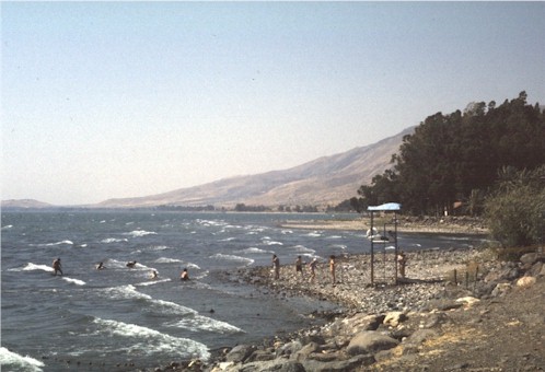
Lake Gennesareth
Large fresh-water
lake (40,000 acres) about 15 miles long & 8 miles wide in
the central Jordan valley. Its surface lies 640 feet below the
level of the Mediterranean Sea about 25 miles to the east.
Except for narrow strips of fertile coastal plain on its
northwestern & southern shores, it is ringed by steep slopes
on all sides. Valleys through the mountains to the west &
east provide natural routes for commerce, but also channel winds
that still produce sudden storms that raise 7 foot waves on the
normally placid lake.
In the Hellenistic & Roman era the
lake was called Gennesareth, after the west shore plain that in
the time of ancient Israel had been dominated by the fortified
city of Kinnereth. In the
1st c. CE the west bank was in the
province of Galilee,
while the east bank was divided between Golan
in the north & the Decapolis
in the south.
Fed by the mountain waters of the Jordan &
nurtured by the spawning grounds of the swampy Lake Huleh 10
miles to the north, Lake Gennesareth has been the base of a
prosperous fishing industry since pre-historic times. The towns
on the northwestern shore from Bethsaida
to Capernaum
to Magdala were originally fishing villages, which had developed
a regional network of commerce. Seasonal flooding & silting,
enhanced by a subtropical climate, made the coastal plain
exceptionally fertile.
The population around the lake increased
dramatically in the 1st c. CE,
sparked by Philip's
transformation of Bethsaida into a major city & Antipas'
foundation of Tiberias
on the southwestern shore. Except for occasional trips across
the lake into the Golan or Decapolis, the center of Jesus'
public activity reported in the gospels was the 10 mile strip on
the northwestern shore of the lake.


![]()

![]()
![]()
![]() Perspective
on the World of Jesus
Perspective
on the World of Jesus ![]()